No products in the cart.: $0.00

On Sale!


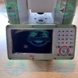
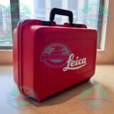
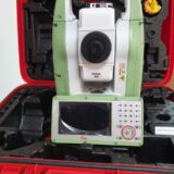


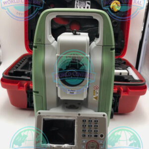
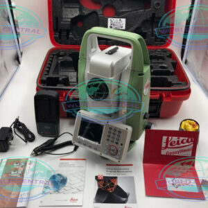
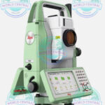
Leica TS10 R1000 Robotic Total Station
The Leica FlexLine TS10 Manual Total Station is a premium surveying solution designed for high-precision measurements, advanced 3D workflows, and efficient field operations. Featuring Leica Captivate software, AutoHeight technology, long-range reflectorless EDM, and rugged IP66 protection, the TS10 delivers reliable performance for surveying, construction, and civil engineering applications.
Delivery and return
Delivery and return
Shipping Information
Shipping Information
Composition and care
Composition and care
Description
Leica TS10 R1000 Robotic Total Station
Advanced Surveying Performance with Leica TS10 R1000 Robotic Total Station
The Leica TS10 R1000 Robotic Total Station is a high-performance surveying instrument designed for professionals who require precision, automation, and efficient field workflows. Built with advanced robotic technology, the TS10 delivers accurate measurements, seamless connectivity, and powerful data handling capabilities for construction, engineering, topographic surveying, and infrastructure projects.
Engineered by Leica Geosystems, the TS10 R1000 combines intelligent automation with reliable long-range reflectorless measurement technology. This robotic total station supports one-person operation, helping survey teams improve productivity while reducing operational costs.
The instrument is ideal for demanding field environments where speed, accuracy, and dependable performance are essential.
Why Choose Leica TS10 R1000 Robotic Total Station
Efficient One-Person Surveying Operations
The robotic functionality allows surveyors to perform tasks independently without requiring additional crew members. Automatic target tracking and motorized movement significantly increase field efficiency.
High-Precision Angle and Distance Measurement
The TS10 R1000 provides exceptional measurement precision for control surveys, stakeout operations, and engineering projects.
Long-Range Reflectorless EDM
With reflectorless measurement capability up to 1000 meters, the instrument can safely measure inaccessible or hazardous locations.
Seamless Data Integration
The TS10 integrates easily with Leica field software, GNSS systems, and BIM workflows, enabling smooth project coordination and digital data management.
Rugged Field-Ready Design
Built for harsh outdoor conditions, the TS10 features a durable housing with weather-resistant protection for reliable operation in dust, rain, and extreme temperatures.
Key Features of Leica TS10 R1000 Robotic Total Station
Robotic Motorized Technology
The TS10 uses advanced robotic motors for automatic prism tracking and precise positioning.
Benefits
- Faster surveying workflows
- Reduced manpower requirements
- Improved measurement consistency
- Enhanced stakeout efficiency
ATRplus Automatic Target Recognition
ATRplus technology enables stable prism locking even in difficult environments.
Advantages
- Reliable prism tracking
- Reduced interruption during operation
- Better performance in crowded construction sites
- Increased productivity in dynamic conditions
PinPoint R1000 Reflectorless EDM
Leica’s PinPoint EDM technology delivers highly accurate distance measurements.
Applications
- Building facade measurement
- Structural surveys
- Tunnel and bridge projects
- Industrial plant mapping
Captivate Field Software
The TS10 is powered by Leica Captivate software featuring intuitive touchscreen operation and 3D visualization.
Software Features
- User-friendly interface
- Real-time data visualization
- CAD support
- Stakeout guidance
- Cloud data synchronization
Leica TS10 R1000 Robotic Total Station Specifications
General Specifications
| Specification | Details |
|---|---|
| Product Name | Leica TS10 R1000 Robotic Total Station |
| Instrument Type | Robotic Total Station |
| Manufacturer | Leica Geosystems |
| Operation Mode | Robotic / Motorized |
| Application | Surveying, Construction, Engineering, Mapping |
| Display | High-resolution color touchscreen |
| Keyboard | Full alphanumeric keyboard |
| Operating System | Leica Captivate |
| Data Storage | Internal memory & USB support |
| Communication | Bluetooth, WLAN, USB |
| Protection Rating | IP66 |
| Weight | Approx. 5.3 – 5.5 kg |
| Power Supply | Rechargeable Li-Ion battery |
| Battery Operating Time | Up to 8 hours |
| Working Temperature | -20°C to +50°C |
| Storage Temperature | -40°C to +70°C |
Angle Measurement Specifications
| Specification | Details |
|---|---|
| Angle Accuracy Options | 1”, 2”, 3”, 5” |
| Measurement Method | Absolute continuous reading |
| Horizontal Angle Reading | 0.1” |
| Vertical Angle Reading | 0.1” |
| Compensation System | Quad-axis compensator |
| Compensator Working Range | ±4’ |
| Angle Display Resolution | 0.1” |
Distance Measurement Specifications
| Specification | Prism Mode | Reflectorless Mode |
|---|---|---|
| Measurement Range | Up to 10,000 m | Up to 1,000 m |
| Accuracy | 1 mm + 1.5 ppm | 2 mm + 2 ppm |
| Measurement Time | Typical 0.8 sec | Typical 1.5 sec |
| EDM Technology | PinPoint EDM | PinPoint EDM |
Robotic & Tracking Specifications
| Specification | Details |
|---|---|
| Robotic Function | Yes |
| Automatic Target Recognition | ATRplus |
| Target Tracking Speed | High-speed servo tracking |
| Search Function | PowerSearch compatible |
| Motorized Rotation Speed | Up to 180°/sec |
| One-Person Operation | Supported |
| Dynamic Lock | Available |
Imaging & Visualization Features
| Specification | Details |
|---|---|
| Camera Support | Optional overview and telescope camera |
| Live Video Streaming | Supported |
| Touchscreen Navigation | Yes |
| 3D Data Visualization | Yes |
| Remote Access Capability | Supported |
Connectivity Specifications
| Specification | Details |
|---|---|
| Bluetooth | Integrated |
| WLAN | Integrated |
| USB Port | Yes |
| SD Card Support | Yes |
| GNSS Integration | Supported |
| Cloud Connectivity | Leica Exchange compatible |
| Controller Compatibility | Leica CS20, CS35 |
Environmental Specifications
| Specification | Details |
|---|---|
| Dust Protection | IP66 |
| Water Resistance | IP66 |
| Humidity Resistance | Up to 95% non-condensing |
| Shock Resistance | Field ruggedized design |
| Operating Altitude | Suitable for high-altitude environments |
Applications of Leica TS10 R1000 Robotic Total Station
Construction Surveying
The TS10 provides precise layout and stakeout functions for building construction, highways, and infrastructure projects.
Topographic Mapping
Surveyors can efficiently capture terrain and site information with fast robotic measurements.
Mining and Quarry Survey
The reflectorless EDM allows safe measurement of dangerous or inaccessible mining areas.
Industrial Measurement
Ideal for plant construction, steel fabrication, and industrial alignment applications.

There are no reviews yet.