No products in the cart.: $0.00

On Sale!


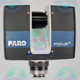
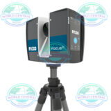
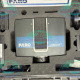


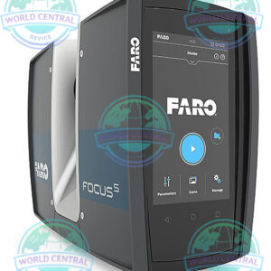
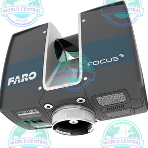
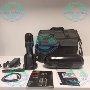
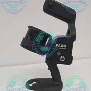
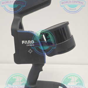
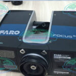
FARO Focus M70 Professional 3D Scanner
The FARO Focus M70 Professional 3D Scanner delivers accurate 3D reality capture, HDR imaging, and BIM-ready point cloud data with a 70-meter scanning range for construction, surveying, engineering, and forensic applications.
Delivery and return
Delivery and return
Shipping Information
Shipping Information
Composition and care
Composition and care
Description
FARO Focus M70 Professional 3D Scanner
Professional 3D Laser Scanning Solution for Construction, BIM, Surveying & Forensics
The FARO Focus M70 Professional 3D Scanner is a compact, high-precision terrestrial laser scanner engineered for architects, surveyors, engineers, construction professionals, and forensic investigators. Designed to deliver fast reality-capture workflows, the Focus M70 captures highly detailed point cloud data for Building Information Modeling (BIM), as-built documentation, industrial inspection, facility management, heritage preservation, and public safety applications.
With a scanning range of up to 70 meters, advanced HDR imaging, onboard touchscreen control, and lightweight portability, the FARO Focus M70 provides an efficient entry point into professional-grade 3D laser scanning while maintaining the accuracy and reliability required for demanding projects.
Why Choose FARO Focus M70?
High-Speed Reality Capture
The scanner captures up to 500,000 measurement points per second, enabling rapid site documentation while reducing field time and improving project efficiency.
Compact and Lightweight Design
Built for mobility, the Focus M70 can easily be transported between job sites, making it ideal for indoor and outdoor scanning projects.
BIM & Digital Twin Ready
Generate accurate point clouds for:
- Building Information Modeling (BIM)
- Architectural documentation
- Facility management
- Construction verification
- Industrial plant modeling
- Infrastructure inspection
- Digital twin creation
Outdoor Scanning Capability
Its IP54-rated housing provides protection against dust and water splashes, allowing reliable operation in challenging environments.
HDR Photography Integration
Integrated HDR imaging captures realistic color information that can be merged directly with point cloud data for enhanced visualization and documentation.
Main Applications
Architecture & Building Documentation
- Existing condition surveys
- Renovation planning
- Heritage preservation
- Historic building digitization
- Façade analysis
Construction & BIM
Construction Verification
- Progress monitoring
- Clash detection
- Quality assurance
- As-built modeling
Site Documentation
- Accurate measurements
- Digital archives
- Remote collaboration
Industrial Facilities
- Factory layout documentation
- Plant retrofitting
- Equipment positioning
- Asset management
Public Safety & Forensics
- Crime scene documentation
- Accident reconstruction
- Evidence preservation
- Courtroom visualization
Surveying & Engineering
- Topographic surveys
- Structural analysis
- Infrastructure inspections
- Utility mapping
Key Features
70-Meter Scanning Range
Designed specifically for projects requiring accurate measurements within medium-range environments while maintaining professional-level precision.
High Accuracy
Delivers measurement accuracy of approximately ±3 mm, making it suitable for engineering, architectural, and forensic applications.
360° Full-Dome Scanning
Captures complete environments with:
- 360° horizontal field of view
- 300°+ vertical field of view
allowing comprehensive site coverage.
Integrated Touchscreen
Easy field operation through an intuitive onboard touchscreen interface.
Wi-Fi Connectivity
Supports wireless scanner control, data transfer, and remote operation using compatible devices.
Specification
| Category | Specification |
|---|---|
| Product Name | FARO Focus M70 Professional 3D Scanner |
| Scanner Type | Terrestrial Laser Scanner |
| Technology | Phase-Based Laser Scanning |
| Intended Applications | BIM, Construction, Surveying, Forensics, Industrial Documentation |
| Maximum Range | 70 m (229.6 ft) |
| Minimum Range | 0.6 m |
| Measurement Accuracy | ±3 mm |
| Measurement Speed | Up to 500,000 points/sec |
| Horizontal Field of View | 360° |
| Vertical Field of View | 300°+ (approximately 305°) |
| Scan Resolution Options | Multiple user-selectable settings |
| HDR Imaging | Yes |
| Color Capture | Integrated Camera System |
| Color Resolution | Up to 70 Megapixels |
| Laser Class | Class 1 |
| Laser Wavelength | 1550 nm |
| Beam Divergence | 0.3 mrad |
| Ingress Protection Rating | IP54 |
| Dual-Axis Compensator | Yes |
| Leveling Accuracy | 0.015° |
| Compensator Range | ±5° |
| Compass | Integrated Electronic Compass |
| Height Sensor | Integrated Barometric Sensor |
| Touchscreen Display | Yes |
| Wireless Connectivity | Wi-Fi WLAN |
| Remote Control Capability | Yes |
| Storage Media | SD / SDHC / SDXC Cards |
| Included Storage Capacity | 32 GB SD Card |
| Data Formats | Point Cloud Data |
| Registration Compatibility | FARO SCENE Software |
| Third-Party Software Support | Yes |
| Indoor Scanning | Yes |
| Outdoor Scanning | Yes |
| Operating Environment | Construction & Industrial Sites |
| Power Supply | Rechargeable Battery System |
| Mounting Interface | Standard Survey Tripod Mount |
| Real-Time Visualization | Supported |
| BIM Workflow Compatibility | Revit, AutoCAD, Navisworks, BIM Platforms |
| Digital Twin Integration | Supported |
| Point Cloud Export | Multiple Industry Formats |
| Project Types | Building, Infrastructure, Industrial, Public Safety |
| Deployment Time | Fast Setup and Operation |
| Portability | Lightweight Compact Design |

There are no reviews yet.