No products in the cart.: $0.00


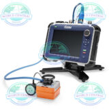
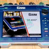
GSSI SIR 4000 GPR System
The GSSI SIR 4000 GPR System is a professional ground penetrating radar platform designed for utility detection, concrete inspection, pavement analysis, and subsurface investigations with advanced real-time imaging capabilities.
Delivery and return
Delivery and return
Shipping Information
Shipping Information
Composition and care
Composition and care
Description
GSSI SIR 4000 GPR System – Advanced Ground Penetrating Radar Solution
The GSSI SIR 4000 GPR System is a professional-grade ground penetrating radar platform engineered for subsurface investigation, utility locating, concrete inspection, geophysical surveying, and infrastructure assessment. Developed by Geophysical Survey Systems, Inc. (GSSI), the SIR 4000 combines rugged field performance with high-speed data acquisition and advanced radar imaging capabilities.
Designed for demanding field environments, the system delivers real-time visualization, enhanced target detection, and compatibility with a wide range of antennas for multiple applications. The SIR 4000 is widely used by utility contractors, civil engineers, archaeologists, transportation agencies, and forensic investigators worldwide.
What is the GSSI SIR 4000 GPR System?
The SIR 4000 is a portable control unit used with GSSI antennas to perform non-destructive subsurface scanning. Ground Penetrating Radar (GPR) technology transmits electromagnetic signals into materials and records reflections from underground structures or embedded objects.
The system can detect:
- Underground utilities
- Reinforcing steel
- Voids and cavities
- Concrete thickness
- Pipes and conduits
- Geological layers
- Buried objects
- Pavement conditions
The SIR 4000 platform supports both single-frequency and dual-frequency antennas for enhanced flexibility across different survey requirements.
Key Features of the GSSI SIR 4000
Rugged Portable Design
The SIR 4000 is built for harsh field conditions with a durable housing and weather-resistant construction.
Field Advantages
- Lightweight portable configuration
- Outdoor-readable display
- Shock-resistant structure
- Reliable operation in extreme environments
High-Speed Data Acquisition
The system captures radar data quickly and accurately for real-time analysis.
Benefits
- Faster project completion
- Improved target resolution
- Efficient utility mapping
- Reduced downtime in the field
System
Antenna Support Compatible with all GSSI antennas
Number of Channels: Records data from 1 single-frequency antenna or 1 dual-frequency antenna
Data Storage: 32 GB
Display Enhanced 10.4” LED display with internal high brightness, Active matrix 1024 x 768 resolution and 32-bit color
GPS: Data logged internally
Display Modes: Linescan, Linescan plus O-scope, Wiggle trace Full 3D, 256 color bins are used to represent the amplitude and polarity of the sign
Data Acquisition
Data Format: RADAN (.dzt)
Output Data Format: 32-bit
Scan Interval: User-selectable, up to 400 scans/sec
Number of Samples per Scan: 256, 512, 1024, 2048, 4096, 8192, 16384
Operating Modes: Continuous (time) or survey wheel (distance triggered) or point mode
Time Range: 0-20,000 nanoseconds full scale, user-selectableGain: manual adjustment from -42 to +126 dBNumber of segments in gain curve is user-selectable from 1 to 8S
Standard Real-Time Filters: Infinite Impulse Response (IIR) – Low and High Pass, vertical and horizontalFinite Impulse Response (FIR) – Low and High Pass, vertical and horizontal
Advanced Real-Time Filters: Migration, Surface Position Tracking, Signal Noise Floor Tracking, Adaptive Background Removal
Automatic System Setups: Storage of an unlimited number of system setup files for different survey conditions and/or antenna deployment configurations
Automatic Antenna Recognition: Automatic recognition of Smart Antennas to allow maximum compliant transmit rate
Advanced Digital Signal Processing
Sophisticated processing algorithms improve interpretation accuracy and target visibility.
Processing Features
- Background filtering
- Gain adjustment
- Real-time signal enhancement
- Migration processing
- Target highlighting
Compatible Antenna Types
- Concrete inspection antennas
- Utility locating antennas
- Bridge deck antennas
- Deep penetration antennas
- Dual-frequency antennas
Applications of the GSSI SIR 4000
Utility Detection
The system is widely used to locate underground utilities before excavation.
Detectable Utilities
- Water lines
- Gas pipes
- Fiber optic cables
- Electrical conduits
- Sewer systems
Concrete Scanning
The SIR 4000 helps contractors and engineers inspect reinforced concrete structures.
Concrete Inspection Tasks
- Rebar locating
- Post-tension cable detection
- Slab thickness measurement
- Void detection
- Conduit mapping
Transportation Infrastructure
Transportation agencies use the system for pavement and bridge analysis.
Infrastructure Applications
- Asphalt thickness measurement
- Bridge deck inspection
- Road condition assessment
- Tunnel investigations
Archaeology & Forensics
Ground penetrating radar is useful for non-invasive investigations.
Common Uses
- Archaeological mapping
- Grave detection
- Buried structure identification
- Historical site preservation
How the GSSI SIR 4000 Works
The system emits electromagnetic pulses into the ground or structure through a connected antenna. When signals encounter changes in material properties, reflections return to the antenna and are processed into radargrams.
Operators can interpret these images to identify:
- Object depth
- Material boundaries
- Underground anomalies
- Structural conditions
Higher frequency antennas provide better resolution but shallower penetration, while lower frequencies allow deeper scanning with reduced detail.
Advantages of the GSSI SIR 4000
Non-Destructive Testing
The system allows inspection without drilling, cutting, or excavation.
Real-Time Imaging
Operators can instantly view subsurface data directly on the display.
Flexible Survey Options
The SIR 4000 supports numerous antenna combinations for multiple industries.
Reliable Data Collection
Advanced digital processing improves accuracy and repeatability.
GSSI SIR 4000 GPR System Specifications
Technical Specifications
| Specification | Details |
|---|---|
| Manufacturer | Geophysical Survey Systems, Inc. (GSSI) |
| Product Name | SIR 4000 |
| Product Type | Ground Penetrating Radar (GPR) System |
| Technology | Electromagnetic Subsurface Imaging |
| Display Type | High-Resolution Color Display |
| Screen Visibility | Outdoor Sunlight Readable |
| Operating Interface | Touchscreen + Keypad Controls |
| Data Acquisition | High-Speed Digital Sampling |
| Signal Processing | Real-Time DSP |
| Supported Antennas | Single & Dual Frequency GSSI Antennas |
| Frequency Range | Depends on antenna selection |
| Antenna Compatibility | UtilityScan, StructureScan, BridgeScan |
| Survey Modes | Line Scan, Grid Scan |
| Positioning Support | Optional GPS Integration |
| Data Storage | Internal Storage + External Export |
| File Export Formats | Industry Compatible Formats |
| Connectivity | USB / Ethernet |
| Wireless Capability | Optional |
| Power Supply | Rechargeable Battery System |
| Battery Runtime | Extended Field Operation |
| Environmental Rating | Field Ruggedized |
| Operating Temperature | Wide Industrial Range |
| Construction | Shock Resistant Housing |
| Real-Time Interpretation | Yes |
| Gain Controls | Adjustable |
| Filtering Functions | Advanced Signal Filtering |
| Depth Penetration | Application Dependent |
| Depth Calibration | Yes |
| Survey Wheel Support | Yes |
| Language Support | Multiple Languages |
| Software Compatibility | RADAN Software |
| Concrete Scanning | Supported |
| Utility Locating | Supported |
| Pavement Analysis | Supported |
| Archaeological Surveys | Supported |
| Void Detection | Supported |
| GIS Integration | Optional |
| Data Annotation | Yes |
| Image Capture | Yes |
| Reporting Features | Yes |
| System Portability | Portable Field Unit |
| Training Availability | Manufacturer Training Programs |
| Country of Origin | United States |
| Typical Industries | Construction, Engineering, Geophysics |
| Compliance | Industrial & Safety Standards |
Industries Using the SIR 4000
| Industry | Typical Use |
|---|---|
| Construction | Utility locating & concrete scanning |
| Transportation | Pavement and bridge inspection |
| Engineering | Structural analysis |
| Archaeology | Subsurface mapping |
| Environmental | Soil and void investigations |
| Public Utilities | Underground infrastructure detection |
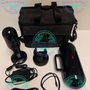
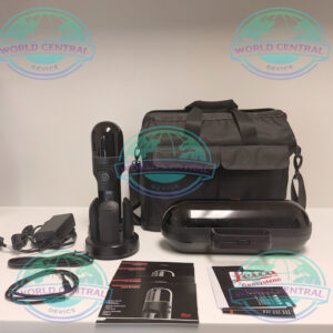
Includes:
GSSI SIR-4000 Control Unit
GSSI 350 HS Antenna
LineTrac utility detection accessory
SIR 4000 sunshade
SIR 4000 AC/DC power supply
All-terrain Forklift
2 m Antenna Cable
Lithium-ion battery
Dual-bay battery charger
Robust transport case for SIR4000
4-wheel cart
Transit case
AC Adapter
Sun shield


There are no reviews yet.