No products in the cart.: $0.00

On Sale!


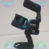
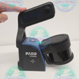


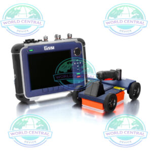
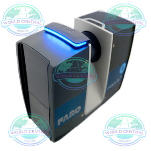
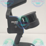
FARO Orbis Premium Mobile Mapping Scanner
The FARO Orbis Premium Mobile Mapping Scanner is a next-generation SLAM-based reality capture system designed for rapid indoor and outdoor mapping. Combining advanced LiDAR technology, real-time point cloud generation, wearable mobility, and digital twin-ready workflows, it enables surveyors, engineers, and construction professionals to capture accurate spatial data faster than traditional laser scanning methods.
Delivery and return
Delivery and return
Shipping Information
Shipping Information
Composition and care
Composition and care
Description
FARO Orbis Premium Mobile Mapping Scanner
The FARO Orbis Premium Mobile Mapping Scanner is an advanced handheld and wearable reality capture system designed to rapidly collect accurate 3D spatial data across indoor and outdoor environments. Combining cutting-edge LiDAR technology, simultaneous localization and mapping (SLAM), panoramic imaging, and real-time data acquisition, the Orbis Premium enables professionals to create high-quality digital twins, point clouds, and geospatial datasets faster than traditional surveying methods.
Designed for surveying, architecture, engineering, construction (AEC), infrastructure management, utilities, mining, public safety, and industrial applications, the FARO Orbis Premium delivers exceptional flexibility by allowing users to capture data while walking through complex environments. The result is faster project completion, increased efficiency, and highly accurate reality capture workflows.
Overview
The FARO Orbis Premium Mobile Mapping Scanner represents the latest evolution in mobile reality capture technology. Unlike traditional static laser scanners that require multiple setups, Orbis Premium continuously captures data while moving through a site, dramatically reducing field time and increasing productivity.
Powered by advanced SLAM algorithms and high-performance LiDAR sensors, the system creates accurate 3D point clouds in real time, making it ideal for large-scale facilities, construction projects, infrastructure corridors, industrial plants, and urban environments.
Key Benefits
- Rapid mobile reality capture
- High-accuracy SLAM technology
- Wearable and handheld operation
- Real-time point cloud generation
- Indoor and outdoor scanning capability
- Digital Twin and BIM-ready workflows
- Large-area mapping efficiency
- Lightweight and portable design
- Advanced LiDAR sensor technology
- Fast project delivery
Applications
Architecture and Building Documentation
Capture existing building conditions quickly and accurately for renovation, restoration, and facility management projects.
Applications include:
- Existing condition surveys
- Building documentation
- Heritage preservation
- Renovation planning
- Facility management
- Space utilization analysis
Building Information Modeling (BIM)
Generate comprehensive datasets for:
- BIM workflows
- As-built modeling
- Construction verification
- Digital twin creation
- Facility lifecycle management
- Project coordination
Construction and Infrastructure
Improve project efficiency through:
- Construction progress monitoring
- Site verification
- Quality assurance
- Infrastructure inspection
- Road and bridge documentation
- Utility mapping
Industrial Facilities
Ideal for:
- Manufacturing plants
- Process facilities
- Refineries
- Power plants
- Warehouse documentation
- Asset management
Public Safety and Emergency Response
Used for:
- Crime scene documentation
- Disaster assessment
- Emergency response planning
- Accident reconstruction
- Security assessments
Mining and Natural Resources
Support:
- Mine mapping
- Tunnel documentation
- Geological surveys
- Resource planning
- Environmental monitoring
Key Features
Mobile SLAM-Based Mapping
The integrated SLAM engine continuously calculates position and orientation while capturing LiDAR data, enabling rapid mapping without GPS dependency in indoor environments.
High-Performance LiDAR Technology
Capture millions of points across large areas while maintaining detailed spatial accuracy.
Wearable and Handheld Operation
Operate the scanner in multiple configurations to maximize flexibility across various project environments.
Real-Time Data Visualization
View scanning progress during data acquisition to ensure complete coverage.
Indoor and Outdoor Capability
Capture reality data in buildings, industrial facilities, infrastructure corridors, and outdoor environments.
Digital Twin Ready
Produce detailed datasets suitable for BIM, GIS, CAD, and Digital Twin applications.
Efficient Large-Scale Mapping
Survey extensive facilities and infrastructure projects significantly faster than static laser scanning methods.
Lightweight Portable Design
Designed for mobility, comfort, and extended field operations.
Specifications
| Category | Specification |
|---|---|
| Product Name | FARO Orbis Premium Mobile Mapping Scanner |
| Scanner Type | Mobile Mapping System |
| Mapping Technology | SLAM-Based Mobile LiDAR Mapping |
| Reality Capture Technology | LiDAR + Visual Imaging |
| Operating Modes | Handheld, Wearable Mobile Mapping |
| Positioning Technology | Simultaneous Localization and Mapping (SLAM) |
| Data Capture Method | Continuous Mobile Scanning |
| LiDAR Sensor Type | High-Performance Survey-Grade LiDAR |
| Laser Classification | Class 1 Laser |
| Point Cloud Generation | Real-Time |
| Real-Time Visualization | Supported |
| Mobile Mapping Workflow | Yes |
| Indoor Mapping | Yes |
| Outdoor Mapping | Yes |
| Underground Mapping | Supported |
| GPS Dependency | Not Required for Indoor Mapping |
| SLAM Processing | Advanced Integrated SLAM Engine |
| Digital Twin Ready | Yes |
| BIM Integration | Yes |
| GIS Integration | Yes |
| CAD Compatibility | Yes |
| Infrastructure Mapping | Supported |
| Industrial Mapping | Supported |
| Construction Documentation | Supported |
| Utility Mapping | Supported |
| Mining Applications | Supported |
| Heritage Preservation | Supported |
| Public Safety Applications | Supported |
| Surveying Applications | Supported |
| Point Cloud Colorization | Supported |
| Imaging System | Integrated Panoramic Camera |
| Panoramic Imaging | Yes |
| Image-Based Documentation | Yes |
| Data Storage | High-Speed Internal Storage |
| Wireless Connectivity | Supported |
| Mobile Device Connectivity | Supported |
| Real-Time Monitoring | Supported |
| Software Platform | FARO Connect |
| Data Processing Software | FARO Connect Software |
| Point Cloud Export | Multiple Industry Formats |
| BIM Workflow Compatibility | Autodesk Revit, Navisworks, AutoCAD |
| GIS Compatibility | Major GIS Platforms |
| Cloud Collaboration | Supported |
| Digital Twin Platforms | Supported |
| Weight | Lightweight Portable Design |
| Power Source | Rechargeable Battery System |
| Battery Operation | Field Replaceable |
| Battery Runtime | Extended Field Operation |
| Environmental Usage | Indoor and Outdoor |
| Portability | High |
| Rugged Design | Yes |
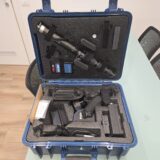
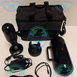
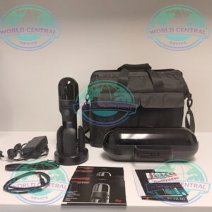
| Transportation Case | Included |
| Firmware Upgradeable | Yes |
| Data Security | Enterprise-Level Workflow Support |
| Typical Users | Surveyors, Engineers, BIM Professionals, Construction Teams |
| Project Types | Buildings, Infrastructure, Industrial Sites, Utilities, Mining |
| Deployment Time | Minimal Setup Required |
| Workflow Efficiency | High-Speed Mobile Data Collection |

There are no reviews yet.